If you are just tuning in, start at Day 1 for the story of our 3 generation family taking a mega-vacation to the Pacific Northwest
Day 17-
Morning arrived at our tent in La Wis Wis, just outside Mt Rainier National Park. Today our goal was to see Mt St Helens. It was going to be a busy day. We had breakfast, packed all the gear back in the Suburban and car (what a jigsaw puzzle it was), and headed out. After looking at both the east entrance and the west entrance, we had decided to enter from the west so we could go to Johnson Observatory and Visitor's center. Even though it wasn't far as the crow flies, it was a stupidly long drive. It's all mountain roads, and we had to drive west almost all the way to the Interstate, then south a little, and then east again. This route followed a wide stream valley, and passed several dam lakes. We stopped to check one out, then continued down the road.

When we had been at Rainier, it had been between cool and cold. As we got more and more toward Mt St Helens, it got hotter and hotter. The high that day ended up being 102. Gross.
As we were driving back eastward again, toward the Mt St Helens National Volcanic Monument, we could start seeing the volcano, but it was hazy and "foggy" looking. Hadn't we had enough fog?
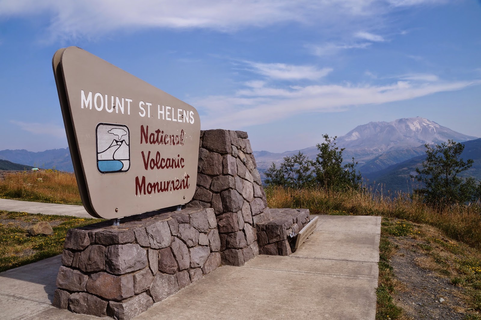
We found out at one of our stops that it wasn't fog. It was super windy up on the mountain that day, and the wind was blowing ash off the slopes into the air. It was ashy out instead of foggy. Hmmmm, interesting.

We stopped at a couple different pull-outs to check out the view, then drove into the "Blast Zone" in the park (it's not actually a National Park).

It was lunchtime, so we headed over to Coldwater Lake to have a picnic. There were picnic tables in the shade, which was a nice break from eating on the curb or the bumper. Once we were done eating, we walked a little ways down the trail by the lake. That lake had not been there before the eruption. All the sludge that poured off the mountain side during the eruption had flowed down and damned up the stream.


In fact we learned that the sludge went 3 different directions, and the road that we came in on followed a river bed that had ash and mud flows for miles and miles and miles.

Back to the car, and up to Johnson Observatory. This building is built on a high ridge, opposite the crater in the side of Mt St Helens.

We got there in time for a Ranger talk on the patio that was extremely interesting. The Ranger spoke like he was excited to share everything about the volcano. There are so many details that we didn't know. He was terrific.

He told us that the initial BLAST blew wind over 600 miles an hour and extremely hot. The forested areas closest, in the direct bath, were decimated. The trees were incinerated or blown to bits. The next zone out, where it had slowed some, the trees were all burned of their branches, and pushed down, all in the direction of the wind.

Then the third zone, the trees were burned dead, but left standing. You could see on the hillsides around him where the different zones were. In the 20 minutes he talked enthusiastically, we learned so much. He also showed us a far off picture taken when the huge plume of ash cloud went up. You could tell the blast came out the side of the mountain, because the plume was entirely to one side of the mountain. The other side was untouched.

We also managed to catch a Junior Ranger program. This ranger had lots of cool props, and used kid volunteers to explain and show how a volcano erupts, and what happened after Mt St Helens blew up. She did a super job, and the kids were glad to earn another Junior Ranger patch.

It was really hot out in the high altitude dry sun. It felt desert like. We went inside, and treated ourselves to watch the 20 minute movie they had in an auditorium. The movie was really well made, fast moving, and had plenty of actual footage. We came away feeling like we had almost lived the event.


Now that we were cooled off a little, we decided to walk a short hike, the Eruption Trail, which goes up a little knoll and back down. there are placards along the way to describe what you are seeing.

Then it was back in the car, and we headed back out of the park.

This night we had a hotel reserved. We knew we'd be needing showers, plus we picked one with a laundry room on site. It was a small odd hotel, but very clean, and super friendly, called the Mount St Helens Hotel. We set to work running the 3 washers and 2 dryers, and went out to eat. We needed some fattening greasy food so we decided on pizza.

Melody's husband, Johnnie, had to depart early the next morning to fly home for work. We kept the kids in our room so they wouldn't be woken up at 6:30 am.
Day 18-
At O-Dark-Thirty, Johnnie quietly left the hotel with the car and drove back to Seattle, to fly back home for work. Now the remaining 5 of us were all sharing the Suburban. Talk about a tight fit.
Today we were heading out to the Columbia Gorge National Scenic something-or-other. We were hoping to get a first-come-first-serve campsite at Ainsworth State Park. We had 4 other places written down just in case, but NONE of the public campgrounds in that area take reservations. We were glad to be driving away from the ugh hot. Of course we had to stop on the way at Fort Vancouver to get a stamp and a quick look around. The boys wanted to see the cannons of course.


The sky turned gray and it started to rain, with lightning streaking in the distance. We couldn't complain too much, as the weather had been fabulous the whole time we'd been in Washington.
Back in the truck we drove into the Columbia River.

First we headed to Ainsworth State Park, to try to get a site early. That was not a problem on a weekday, with plenty of spaces available. We picked out what seemed to be the best site, and set up camp. This would be our camp site for 2 nights, again not having to pack up. That was such a treat.

The weather was still being gray, and threatening rain and thunderstorms. Our plan had been to go climb a tall rock spire trail, but that didn't seem advisable in thunderstorms, so change of plans. First we went down the road and across the river over the Bridge of the Gods, to get groceries in a small town there. The bridge was really pretty. It was named after an area natural stone arch, that the Indians had named Bridge of the Gods.

Groceries bought and stashed in the truck, and it was time to go look at WATERFALLS. This area of the Columbia Gorge has many, many waterfalls pouring off the sides of the cliffs. We drove to Horsetail Falls, which is RIGHT next to the road.

It was sprinkling a little, but we decided to hike the short ways to Upper Horsetail Falls (also called Ponytail Falls). The trail starts by switching back a bunch of times, up, up, up the cliff, then over to the Upper Falls.

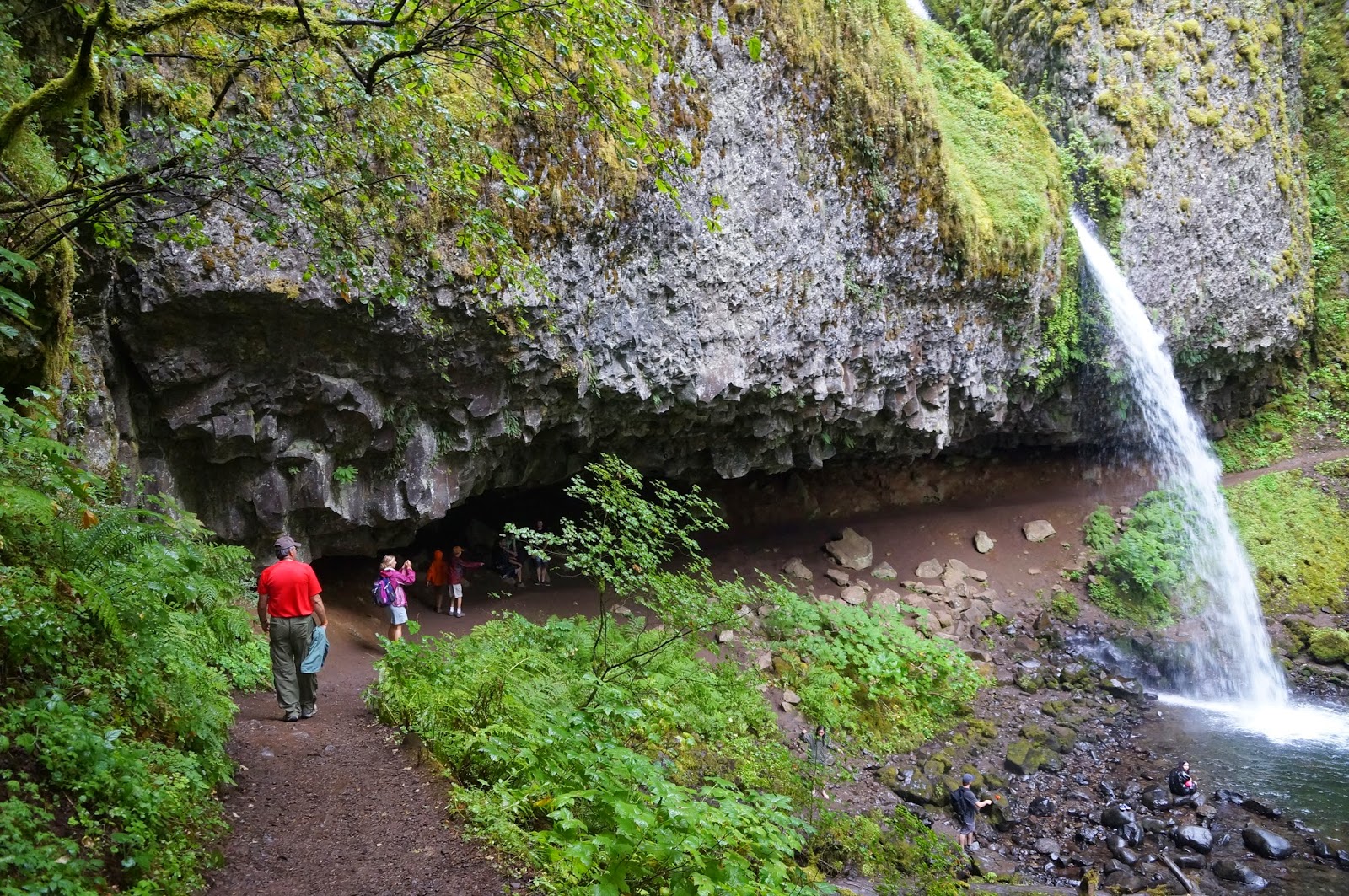
They were really pretty, and we spent some time enjoying them.

By now, it had stopped raining, so we decided to "go for it" and hike the rest of the loop, so we continued on along the clifftop, and over to Upper Oneonta Falls.


Then we finished up the loop as we headed back down, and along the roadside back to the car, passing thru an old tunnel thru the rock.


So, let me insert here what it means to sleep in Columbia Gorge. This is a natural Gorge, where the Columbia River has carved down thru the rock layers over the millennium, leaving cliffs on both sides, and a little bit of flat river bottom. In this relatively narrow space of river bottom, they have crammed an interstate, an old scenic highway, some campgrounds and pull offs where they could squeeze them in, and........a RAILROAD. A BUSY railroad. Which runs RIGHT next to the campgrounds. Freight trains went be every half hour or so. ALL NIGHT. RIGHT NEXT TO OUR TENT. We had unwittingly chosen a site that was THE closest to the tracks. Sometimes, for extra annoyance, they would blast the whistle. All night. I love the sound of trains. But I had my fill those TWO nights that we slept there. And there are tracks on BOTH sides of the river, so we couldn't just move to the Washington side either. Did I mention that freight trains went by our tent all night? On the bright side, the campgrounds had fantastic bathrooms and showers, and the sites were nice......if you like trains
Day 19-
This was an exciting day for me. I was meeting my half-sister for the first time. We have the same father. I was born and raised on the east coast. She lived on the west coast. We were finally going to meet. We had decided to meet at Multnomah Falls for lunch at their restaurant. Meanwhile, we had the morning to go explore. This mornings hike was to hike up into Oneonta Gorge. It is sheer walls on both sides of the stream. You can walk up the stream bed to the base of the falls. The book said it was a half a mile. It seemed shorter. The "hike" starts from the pull off on the side of the road. Once you are in the stream bed, you have to navigate over a very large jumble of logs that have washed down (log jam).


It was tricky to negotiate with the kids, but we got thru. Then we walked up the stream. It was a very scenic walk, The walls to either side of us were hundreds of feet straight up, and green with moss. The stream was small rocks and not to cold to walk in with our water shoes.


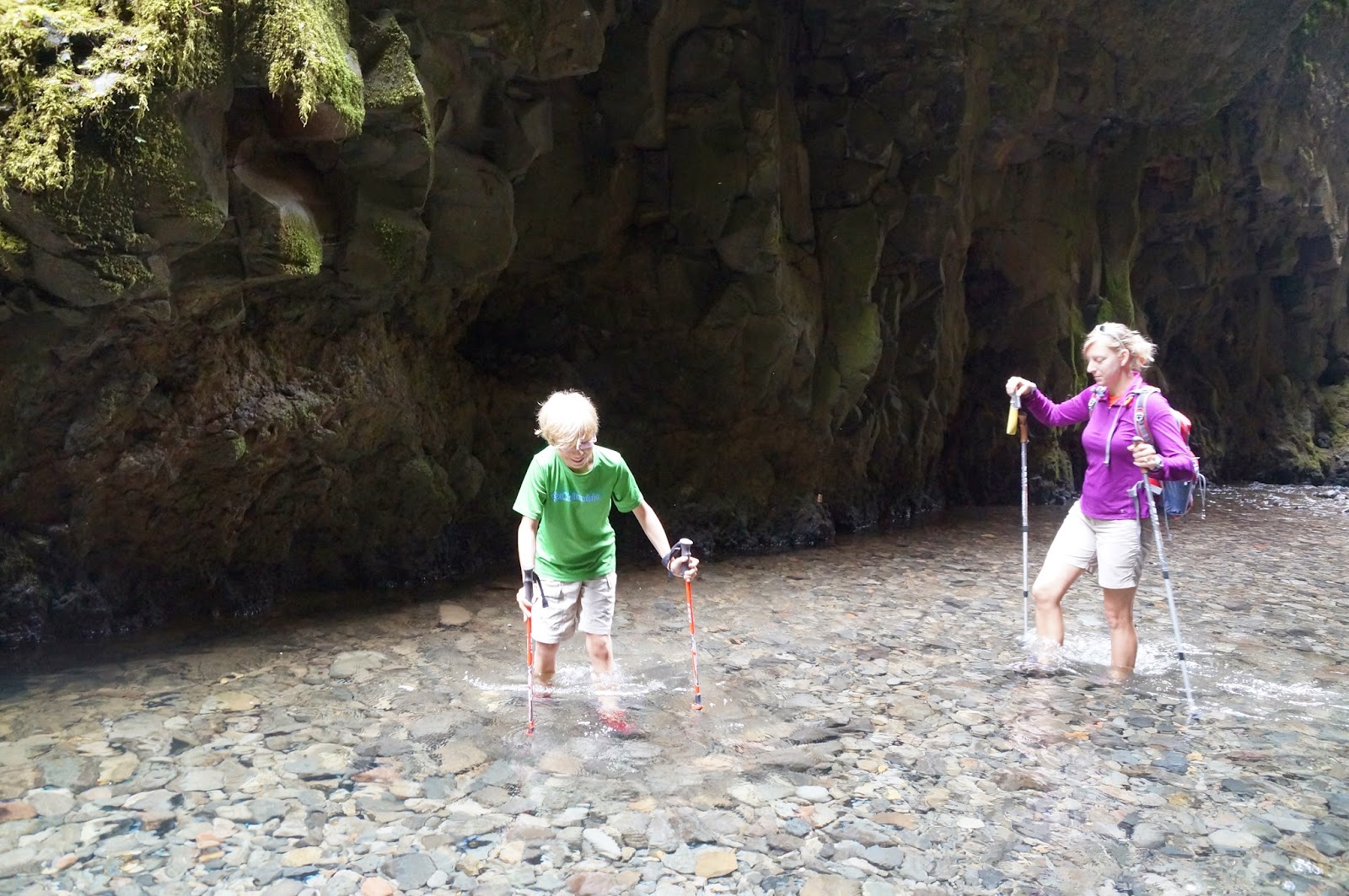
But then........just as we could see a peak of the falls in front of us, we came to a section that was DEEP. We had seen some people that had just come back from that section, and knew that it was armpit deep. We stashed our daypack on the side wall, and Larry put Aiden on his back and started walking. Once you were in above your knees, the water felt COLD. We were all laughing as Larry and Aiden made their way thru and out the other side.

Then it was Chase and Melody's turn. I took up the rear. I had a drybag for my good camera, so I just went on thru. It was COLD. Once on the other side, the falls was right there. Time for lots of pictures, of course.


Then we made our way back thru the deep area, got our day packs back on, and headed back to the car.

We drove the short ways to the campground for dry clothes, and then headed for Multnomah Falls for lunch. My sister Carol got there just after we did. I was so glad to finally meet her in person. She is a wonderful person, and we got to share stories.


We went to look at the Falls first, and then went in for lunch.

The food was great, and the building is an old historic masterpiece. It was really nice. After lunch and some more chatting, we went outside and looked thru the visitors area, then said our goodbyes. I was really sad to be parting from Carol already, but as you can tell, we were trying to cram 6 months worth of sightseeing into just 3 weeks.

Our group headed up the walkway to the bridge that is suspended between the 2 falls. It's really pretty up there.


The trail continues to the top of the upper falls, but we decided no. We had more plans for the day. Back in the car, and we headed back over to the Bridge of the Gods, to go to the Washington side of the Bonneville Dam.

Carol had told us that you could go see underwater at the fish ladders and watch Salmon swim upstream. We found the Visitors Center and, sure, enough, there is a public viewing area under water of the fish swimming UP the dam fish ladders to go spawn.


Wild Salmon have been fished almost to extinction, and dams are prohibiting them from getting back upstream to lay more eggs. The good people in this world are working to change that. We also walked around and saw into the power plant and other features of the dam.

Then back to the car, and we drove down to Beacon Rock. The top of the rock is about 600 ft up above you, towering over the Gorge, and the trail back and forth and back and forth, carved into the rock, is almost a mile long.

The trail was made many years ago by a man that loved the natural feature. He bought the "rock" for $1, then built the trail, taking several years, and then gifted it to the State of Washington.


It was a really fun walk up to the top, with LOTS of views up river and down river, including the dam we had just visited.


After soaking in the view, we walked back down, and headed back to camp. It had been a busy day. Time to get some rest and get in another campfire. And listen to the TRAINS go by.
Another great thing about this campsite? We had electric hookups. We took advantage of it and charged up all of our electronics

Next note. During the middle of the night, there was a longgg drawn out horrible racket from a train that scared the daylights out of both Melody and me. It TRULY sounded like a huge freight train was de-railing and we were going to be crushed right there in our tents. There was metal on metal screeching and clanking. It was NOT the highlight of our trip. All the male members of our group slept thru the whole thing. I laid awake for a while after that. It was UGH.
No comments:
Post a Comment