My daughter and I, plus my husband, and her husband and kids, decided to take a Great Adventure to the Pacific Northwest, in the beautiful state of Washington. In the process of researching what there was to do there, we stumbled across Blogs for the Sahale Glacier camp, high up above Cascade Pass in the Northern Cascades. The more we read about it, the more we knew we wanted to go. This is the highest camp site in the Northern Cascades; wayyyyy above the tree line. There are only a few people permitted per night, and getting a back country permit would be a challenge, as they do not allow advanced reservations. The permits are issued first-come-first-serve starting the day before your hike. To complicate matters, climbers also like to use this as an intermediate camp on the way to the peak of Sahale, and several surrounding mountains. We knew we could end up with no permit, and made a "plan B' just in case. The morning before our hoped-for hiking day, Larry and I left Sedro-Woolly at 4am to go stand on the doorstep of the Back Country office. We came out victorious. We were now holding a permit for our long anticipated hike. All of us were elated (My daughter's husband had left by then, to return to work). We did notice a big sign on the desk in the permit office, that warned that the hike to Sahale Glacier was HARD and "grueling", and that NO camping was allowed anywhere except at the camp itself. You had to make it all the way there, or turn around and come all the way down. Our research had shown that the total hike was 5.9 miles, with the first 3.7 miles averaging 460 ft elevation per mile, and the second part, 2.2 miles of 1020 ft elevation gain per mile. We had done several short hikes at that grade, and knew it would be hard, but we felt that if we just took that part slow, we would have no major problems. The total elevation gain for the hike was to be 3940 ft.
We spent that day driving around the Rt 20 Cascades area and taking small hikes. That night we camped at Marble Creek campgrounds, on Cascade River Road, in the Snoqualmie National Forest.

Who would have thought that a public car-camping place would NOT have running water, anywhere, nowhere to be found. Water bottles needed to be filled for our hike, so finally I asked some other campers where the water was. They promptly pointed to the river, Marble Creek. Hmmmmm.....ok, I guess we're filtering water. No problem. We had forgotten to check if water was available on the hike up the mountain, so we decided to be safe and take plenty of water for the entire hike. We had to filter several gallons of water out of the stream.

Once the water situation was solved and our camp was set up, we reviewed the plans for the next day; hiking up to Sahale Glacier. We calculated that the hike from the parking lot to Cascade Pass, 3.7 miles, would take a couple hours, and then maybe 4 hours max for the remaining 2.2 miles. That would be half a mile per hour. Sounded like TONS of time. We knew it was really steep on top, and didn't want to get there too early so the kids wouldn't be trying to run around too much and fall off a cliff. The plan we came up with was to pack in the morning (it was dusk and we were tired). We could sleep in till 8am, pack our packs, break camp, and be on the trail by 11am. That would put us on Sahale about 6pm for dinner, time enough to revel in the view, cook dinner, catch a sunset, and relax. Sounded like a perfect plan. We relaxed some and hit the sack about 10:30pm.
Next morning came, and we were up and moving right around 8am, just as planned. The weather felt great. We spent a lot of time wondering what weight of clothes to take on a mid-August hike to the mountain. There was no interest in carrying weight we didn't need, but also no interest in freezing our butts off. After much back and forth, we finally got our packs situated, ate breakfast, and broke camp. We had to be creative to get everything in/on the Suburban to drive down to the trail-head, but we finally did it. It was about 11:30 now. We weren't too far off of our 11am mark. Oh, wait. I didn't factor in that we had to drive about 18 miles on a horrible bumpy twisty gravel forest road to get to the trail-head. There goes another half hour. Then to drop off packs at the trail head, find a parking spot (Cascade pass is the most popular day hike in the park) and walk back.

We finally heaved our packs onto our backs at 12:15pm, at an elevation of 3600 ft. . It was 63 degrees out, and felt perfect. We could see there were some foggy clouds hanging on the mountains higher up, but we weren't worried. From the trail head you could periodically hear glaciers crack, boom, and tumble down the Johannesburg mountain side. It was VERY cool sounding to us East-Coasters.


Up the mountain went our procession of 5. Myself and my husband, in the over-the-hill age group, my daughter, in the early middle age group, and 2 kids, ages 7 and 11, both carrying their own gear. We had read about the cougars in the area, and kept the kids between adults the whole time. Cougars will hunt down the weak and the small. There are also bears in these mountains, but no Grizzlies.
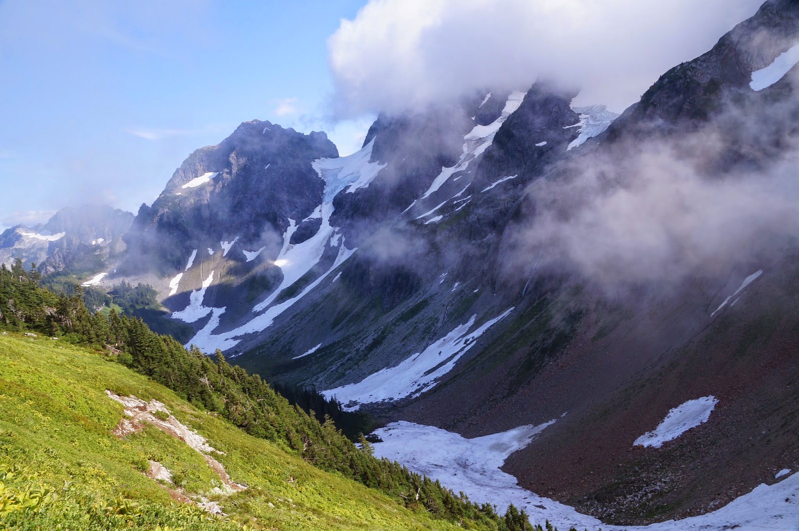
The first thing the trail does, is switch back about a zillion times, climbing thru the evergreen forest on the mountainside. Periodically you would be treated with a view. The views would sometimes be somewhat foggy from the clouds. Then the views became non-views as we climbed well into a thicker cloud.


At about 1:10 we stopped and had lunch and a 20 minute packs-off break. We guessed that we probably had covered 1 1/2 miles. The trail had been steadily ascending, necessitating leaning breaks periodically to catch our breath, but no big deal. Around 1:30 we were on our way again, switch back, switching back, switching back. Finally we got to the top of that section and the trail flanked the side of the ridge, stretching out toward Cascade Pass, with a much less dense tree cover. We were treated to periodic views in shades of fog.

As we went higher, and the tree cover lessened, the wind was picking up and the thermometer was dropping. Hiking up-up-up kept us mostly warm. When we would stop for a break, we would get a little chilly, and then warm up again as we hiked. It felt good not to be sweating our buns off. Hiking along that ridge was enjoyable, and in no time at all, we were at Cascade Pass at 5392 ft elevation. It was now 3:20pm.

We dropped our packs and enjoyed the view, though it was limited by the clouds. The clouds roll in from the west (to east) and run into the Cascade Range here. They will build up enough, and then start to spill over the Pass. You can watch the clouds spill over, like water over a dam. We sat and enjoyed the view, along with plenty of other people. The air was noticeably colder, 46 degrees, and the wind was constantly blowing a stiff breeze. After some digging thru our packs, we layered up a little more. I quietly mussed that it had taken us 3 hours to do the easy 3.7 miles, which privately worried me a little.
Around 4pm we heaved our packs back on and started for the Glacier camp, 2.2 miles ahead, along Sahale Arm trail. This section we had allotted 4 hours for. That would put us in camp about 8pm now, with our snags-so-far in our plan.. That would be really pushing it for day light. I quietly hoped we took a lot less time than that.

We hiked along, enjoying what view we could thru the cloud cover. We passed the cut off trail for Doubtful Lake at about 5:10, but there was no view, just a sea of white clouds. We had gone 1 mile and gained about 800 ft elevation. That's decent time. We passed many people that said encouraging things about the sun peaking out higher and getting above the clouds. We really hoped so. Who wants to go on a hike with incredible views and not be able to see anything? We continued on.


The cloud cover got denser, and the wind got windier. I noticed that the wind blowing the clouds over us was making my hair dripping wet. Soon, everything was covered in a thin film of wet. We would hike some, rest a little, hike some, rest a little. As we felt that we must be getting close, we passed a Ranger going down the mountain. She had been to the camp to check permits, and dutifully checked our also. She then regretfully told us that we had "gone most of the distance" to the camp, but the portion left was VERY steep and rocky. Ugh. NOT what we wanted to hear. At this point, we guesstimate that we were only 3/4 of a mile max from the top, but she was not kidding. Soon we came to a much steeper rock hopping section. Some places it is hard to see where the "trail" goes.


It is a slide area, so they can't "mark" the trail. We kept searching in the fog for the areas that looked most disturbed. A lot of elevation had been gained already, and we are not used to much elevation, so we were having a slow go of it. Travel 50 feet, take a break a minute, travel another 50 feet, repeat. The wind and fog was freezing cold, and we finally gave in, to root thru our packs and pull out the rest of our layers; Gloves, hats, jackets, everything. Aiden, the youngest, was really having a tough go of it on his little legs. Chase and my husband were far ahead. I was somewhere in between, trying to take pictures and keep putting one foot in front of the other. At what must have been half way up that rock field, my husband suggested to me that he and Chase push ahead to the top, and then he would come back for Aiden's pack. It sounded like a great plan.

We kept working our way up the mountain slowly. After maybe half an hour, we actually almost caught up to the ones in front. Turned out that my husband started getting nauseous from the altitude and working hard. He was having a lot of difficulty just hiking. They crested the top when we were close enough to see them thru the fog clouds. A huge sigh of relief went thru us as we finally reached the marker for the camp, at 7686 ft elevation. It was now 8:10pm. It had taken us 8 hours to hike 5.9 miles. JUST as we cleared the top of that rock scramble, we came above the clouds and it cleared enough for us to see a spectacular view with the sun setting, AND the wind died.


After a few minutes of gawking and taking pictures, we started more rock hopping to try to find the 2 sites that were left over for us. Thankfully, they were right next to each other, in a protected alcove. At 8:30 we started setting up camp.

We were all totally tired, and Larry was getting sicker by the minute. We managed to get the 2 tents set up, and get his sleep pad and sleeping bag in one of the tents. He laid down heavily, curled up in a ball, shivering and dizzy. I was so glad I was still ok. While we worked on tent set up, my daughter worked on boiling water for our backpacker dinners, so we could get the kids fed.

Larry couldn't bring himself to eat anything at all. We had dinner, admired the stars, and we all headed for some nice warm sleeping bags. Despite the tiny size of my mountaineering tent, I fell asleep quickly, though not without worrying about Larry.
I can sleep thru anything, but apparently during the night, my daughter listened to a mountain goat wander thru camp, right between the tents.
Morning came, and I woke to sunshine on my tent. I sat up, unzipped the door a little, and WOW WHAT A VIEW.


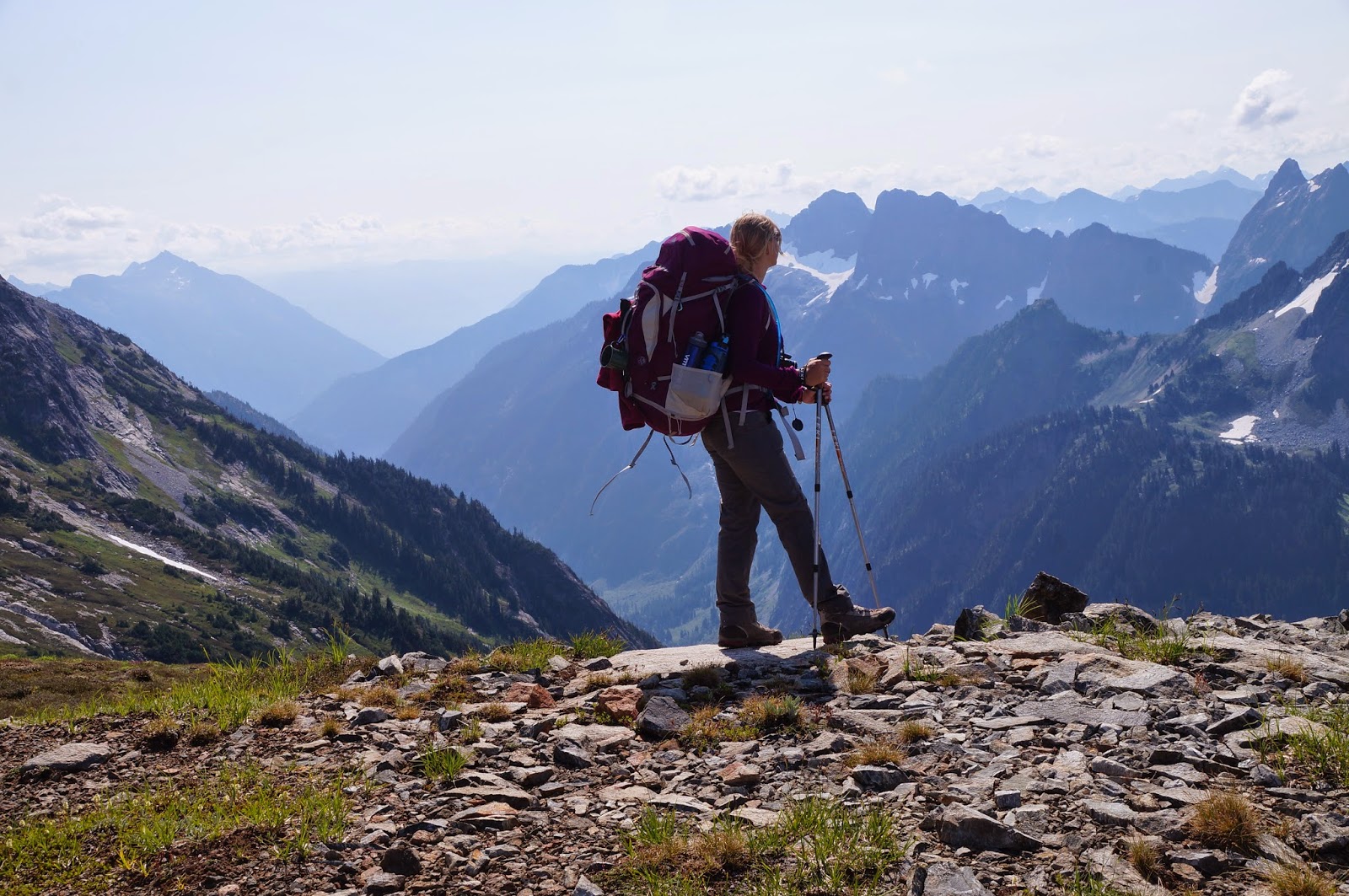
I hurriedly dressed in layers and headed out of the tent. Grabbing my camera, I started walking around and was totally elated at the incredible views before me. It was a gorgeous day, weather wise, and the sun felt so good. From our high perch by the glacier, you could see that everything to the west of the mountain range had a thick low white layer of cottony clouds. Higher mountain peaks poked thru the cloud cover and made little islands. Looking east, everything east of Cascade Pass was clear. You could see for hundreds of miles in both directions. When you looked behind you, you saw Sahale Glacier at your feet, and the peak of Sahale towering above you at 8484 ft tall.


In some areas, you could see down to Doubtful Lake, miles below you down the trail. The trail up Sahale Arm was visible as a thin far away line in the green vegetation that grows on that rounded arm of the mountain. There wasn't a single place in your 360 degree view that wasn't stupendous. I took at least a thousand pictures that day, but NONE of them did the view justice. THIS made the grueling hike worth it.
After trying to get my fill of the scenery, I went back by the tents to check on Larry. He had gotten out of the tent and was sitting in the "kitchen" area. He looked a whole lot less shaky and green. He ate a little, then ate a little more, and then some more. It all stayed down. We started packing up our tent, and then started rousting the kids out of theirs. Breakfast and coffee later, and both tents were down and packed up. We did NOT want to underestimate the length of the trip ahead of us, knowing that going down that steep rock field would not be easy.


The views were still incredible, and we were glad for it, because it made the hard hiking seem so much easier. I could not get enough of it, no matter how much I gazed around. At about 9:30am, we started the trek back down the rocks.


This time, it was walk 50 feet, take 50 pictures, walk 50 feet, repeat. Time passed pleasantly, and before we knew it, we were hiking on Sahale Arm again, with the boulder field just a memory (to our feet they were a BAD memory). As we would pass other rocky areas, Pika would scold us as we went by, disturbing their food hunting. A few times we got to watch them scurry around.


As the trail passed Doubtful Lake, we took a packs off break above it and enjoyed the view while eating a snack. We had not brought lunch, thinking it would be a 4 hour hike down, and we wanted to save the weight. There were plenty of snack in our packs, so we weren't hurting for energy.


Back on the trail, and an easy stretch to get back to Cascade Pass. We arrived at the Pass about 12:30pm. We had done this section of 2.2 miles in 3 hours, but at least half of that time was admiring the views and taking pictures. As we sat there, you could watch the clouds spilling over the pass into the clear areas, and then dissipating. A Marmot wandered around nearby and ate grass, totally not at all afraid of humans.


Another packs off break at the Pass, and lots of snacks, then on our way again. It was now 1pm. Our hike traversed the side of the mountain, and then started the interminable switch backs. One article says there are over 30 switch backs. It feels like 100, but it also makes the slope feel much easier on the knees and feet. Down, down, down some more, with a few short breaks. We hiked thru a few areas of very light fog, but nothing like the day before.


Before you knew it, we were back at the parking lot. It was 4:15pm. A few "We did it" ending pictures, cram all our gear into the cars, and we headed out of there to find civilization and food.

Despite it being, by far, the hardest hike we had ever done, I found it incredibly rewarding. It surely would have had a different end feeling if the clouds had hovered around the entire hike. We were so fortunate to have the weather turn to perfect the second day. Would I go again? In a heart beat. But now I know..........the last mile is VERY HARD, and allow plenty of time to do the hike. Don't be lulled by the 5.9 mile distance. Also, there is water available everywhere. No need to carry much water, just a way to purify it. All this said, this is a "Don't Miss" backpacking trip.Ten stars out of five.
We drove back to my brother's house, back into the horrid Seattle traffic, weary from our adventure, but full of great new memories to last a lifetime.

We spent the next day washing all the dirty clothes, and reorganizing and undertaking the mundane task of getting all that gear to fit back into our suitcases, and keep each one under the 50 pound limit. This necessitated a trip to the Post Office, of course, to mail home some of the small but heavy stuff, like books and rocks.

We left a small mountain of "stuff" for my brother's family to have, like left over unopened food, and some plastic tubs we had bought to keep organized. I was not looking forward to leaving. There were a few things more that I would really have loved to stay and do, but real life was waiting at home for me. I had managed to leave 27 horses and my dog under the care of 2 live in sisters, ages 17 and 21-ish. They had done a fantastic job of taking care of the farm, but I needed to go back and let them go home. So, I said goodbye to the Pacific Northwest the next morning, and boarded a plane to take me back to Virginia.

Our next adventure? Scuba Diving in Bonaire in the spring, and adventuring in Acadia National Park in the summer of 2015. Then in 2016, a hopeful great new adventure in Colorado, at Rocky Mountain National Park, Mesa Verde, Black Canyon of the Gunnison, Great Sand Dunes, Canyonlands, and who knows what.
No comments:
Post a Comment