Backpacking the wild Olympic Coast, Ozette to Rialto Beach

Myself, my husband Larry, My daughter Melody, her husband Johnnie, and my 2 grandsons, Chase age 11 and Aiden age 7, flew out to Washington for a 3 1/2 week adventure in the great outdoors. This is the part of the trip that we hiked the Olympic Coast.
The planning for this backpack started a year before the trip. We read books, looked at maps, and read all we could find on line about the hikes on the coast. The decision was made to do the wildest and most isolated section, from Ozette to Rialto Beach. The total distance was 22 miles, and we decided to savor the trip and take 4 days to do it, especially with a 7 year old. Studying the maps, we decided on our camp sites for each night. There are camp sites marked on the map, and in most areas, you must camp at one of the approved campsites. Seemed like a great plan, so we wouldn't have to "make" our own spots.
This section in partly in the area that has a quota system, so I diligently applied on the first day I was allowed. I sent two possible itineraries, and we got our first choice. Elated that our trip would go as planned, we shifted into high gear for planning. We spent some more time researching, and ended up with some unanswered question. We knew from our research that you had to "hike the tides". It didn't look that hard on the Nat Geo Trails map. There were only a few spots that were marked as danger, and there was only one place that didn't have an alternate over-land trail to get around the headlands if the tide was up. Finally I called the back country office to find out more info. The guy on the phone was super helpful and friendly, and had plenty of great advice. One thing I found out was that the map I had for that area was basically useless. There is a special map that I ordered on line that tells much more detail about the coast line and the tides (called Custom Correct map). Every "squeeze" point is marked with what tide height is the max you can get around that spot. Once the map arrived, I spent plenty of time studying it and the tide charts that came with my permit. It was obvious that "hiking the tides" would be a lot more difficult than I figured. I was comfortable though that we could be diligent and pull it off.
Note- when planning, being from the east coast where the beaches are all long and sandy and smooth, we weren't sure what type of footwear was appropriate for hiking here, water shoes or hiking boots. The answer is HIKING BOOTS. Don't even bother with water shoes. You will definitely want the rigid support of a good pair of waterproof hiking boots. The huge majority of the hike is on all types of rocks. It is rocks, rocks, and more rocks, some with barnacles and mussels, some with enough seaweed to totally encrust the rocks. The closer you are to the ocean's edge, the slicker the rocks. If you have a hankering to get your feet wet, wait till you get to camp, then pull off your boots, and stick your feet in the ice cold water. I tie crocks to the outside of my pack, and wear those in camp, and wore them into the ocean, all 8" of it. It is freezing cold.
Fast forward to
The first day of our hike- Ozette to Yellow Banks
We had camped by Ozette the night before the start of our hike, and driven the rental Suburban to the end of the hike so we would have transportation when we got done.
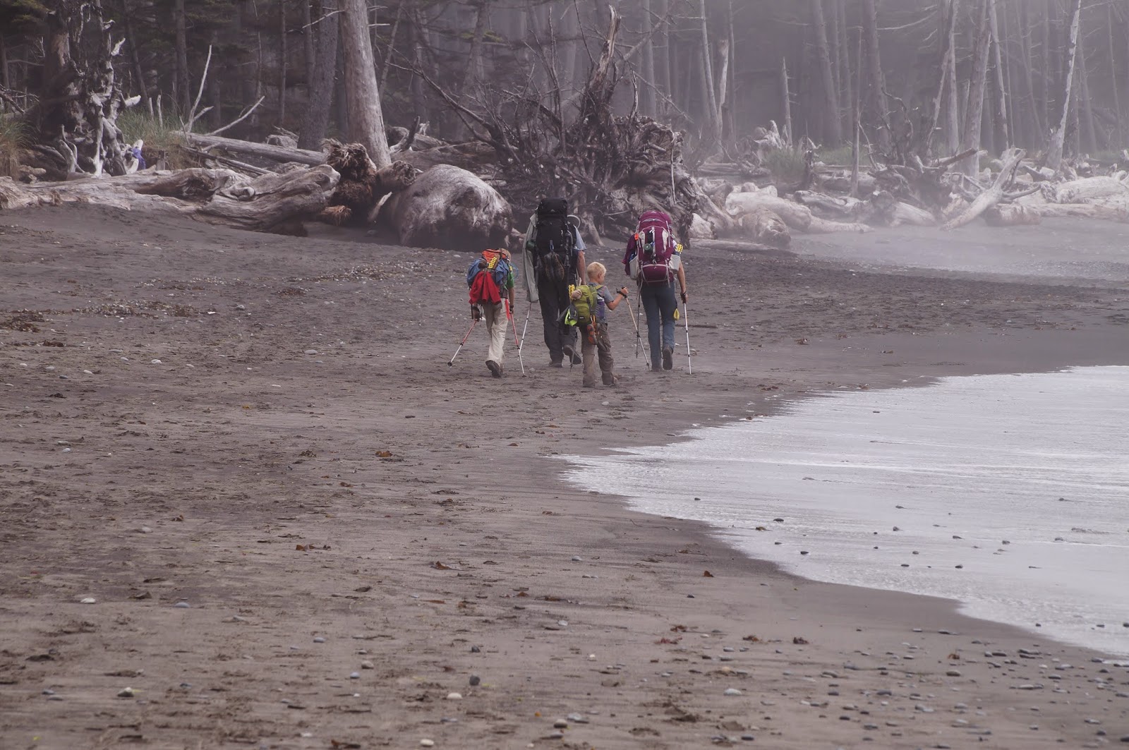
The first day of the hike was a 6 mile stretch from Ozette to Yellow Banks. The first 3 miles was on boardwalk across the piece of land between Ozette and the ocean. Then the trail drops you on Sand Point, a gorgeous wide long swath of sandy beach. The next 1 1/2 miles was on the sand, then a mile and a half of rocks to cross, to get to Yellow Banks. Low tide was scheduled for 11:01am, and the rocky "squeeze" section was almost at the end of the 6 miles. On the map it was listed as needing a 5' tide or lower.
Let me describe a "squeeze". On your right, you have the giant Pacific Ocean. On your left, you have a straight up solid wall of rock. At low tide, you have slippery seaweed huge rocks to climb around the point (headland) on. At high tide, you can NOT get by. If you miss the low tide, you have to go up and over, or wait for the tide to go out. One ranger called it "being between a rock and a wet place". That is NOT where you want to be. There IS some leeway though. The map tells you what the tide height can be, and the tide chart gives you a graph of the tides, so you can look to see what the tide height will be 2 hours before, or 3 hours after, or such.
So, with our map and our tide chart, we felt we would be plenty safe to start at 7:30am. We would rather arrive at the squeeze early, and wait a little, than to arrive late and wait for many hours.


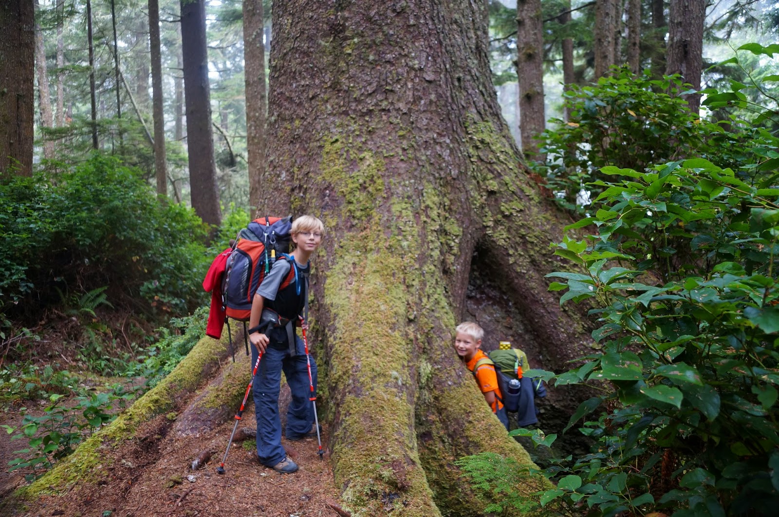
We actually hit the trail at 7:40 in the cool, damp, foggy morning air. The boardwalk was easy going, basically flat, and thru a very green old growth forest. Everything there is green. I have never seen so much moss in my whole life.

We got to Sand Point at 9:15am. We were making great time.

We hiked down the beach some, and then took a packs-off break about 9:40am. There were rocks sticking up out of the sand in lots of places, and star fish were clinging to them in the last little bit of water that had pooled when the tide went out. We were really excited to search for them. We even found a sun star. There was some fog starting to roll in, but it wasn't too concerning.


Back to hiking, and after the mile and a half on the beach, we started rock hopping. We had underestimated how taxing it would be to clamber thru the rocks with a heavy backpack, but we were thrilled with the scenery, so that helped keep our minds off the rocks. That day we saw Ocre Starfish, Acorn Barnacles, Sea Urchins, Anemones, mussels, and more. Everywhere there was even a small amount of sea water, life was colorfully clinging to the rocks.

We cleared the squeeze point with perfect timing.


We passed a guy coming the other way and chatted with him, to see how much further. He told us where to find the "camp". We were not prepared for how completely unmarked and random the camping areas were. We arrived at Yellow Banks (the steep cliffs are yellow here) at 11:45. We couldn't easily figure out where the "camp" was, so we dumped our packs and started exploring. Finally we found the rope the man had described. You had to haul yourself up a very steep bank to the top where there's a group of small cleared spots in the trees.


We got all our gear up there and figured out places to set up tents. Once the tents and sleeping bags were set up, we had lunch, and then relaxed. We were really tired, and we all ended up falling asleep. It was such a luxury. The nap felt great. Up on top of the bank it was substantially more windy and cold than on the shore line, and there was plenty of fog by now. We thought that was odd. While we napped, we got 3 neighbors.
Once we finished our naps (and now we were COLD), we decided we needed to locate the fresh water source that is available at every campsite area. We gathered our water bottles and filter pumps, and climbed back down to the beach, where it was warm again.

We walked down the beach and located the tiny stream. There had been lots of stories about the streams being brown brackish water that tasted off, but the stream we found was nothing like that. The water looked great; only the slightest bit yellow, and it tasted fine. We worked together to fill all the water bottles.
In the process of locating the water, we had found some more tent areas, right on the beach. They looked SO much more inviting. We unanimously decided to move camp. It took a couple trips each, since we didn't want to totally pack up our stuff, but soon enough we were in a far better campsite, right on the ocean on the sand.

We spent the rest of the afternoon and evening exploring, relaxing, reading by a campfire (you can burn driftwood) , making dinner, etc.


The fog cleared out just in time to treat us to a beautiful sunset over the Pacific Ocean. Check that off my bucket list.

Time to review the plan for the next day to decide a wake up time, and then we all headed to bed. The ocean lulled us into a blissful sleep, though it was actually LOUD that night
Note- How did we ever manage without trekking poles when I was young? We rarely go anywhere without them, and they were extremely useful, almost totally necessary, on this hike. Trekking poles are lightweight and collapsible. They fit in a large suitcase. They stash easily on the back of a backpack. Then, when you want them, they are easily expanded to the correct height. They are my best friend. I use them as 2 extra legs when picking my way thru difficult terrain. I use them to test the solidness of an upcoming step. I use them as outriggers when crossing slick streams. I use them as load bearers when stepping down hill or off rocks. I use them as hoists when hauling myself up hill or up over a rock or roots. I use them to poke at things I'm not sure about, like snakes, or slugs (slugs are just gross). I use them to poke into deep grass to "see" what's ahead. They are indispensable. Some hikes, I think that trekking poles should be one of the 10 essentials. You can even use them to jury-rig a shelter with a trash bag. If you hike, and you don't own a pair, go down to REI and get a pair. Talk to the folks about the options. I got the type that press to tighten, and I got cork grips, which do not get slimy and sweaty under your hands. I love mine. Don't leave home without them, and you really want to have them on this Olympic hike.
Day 2 of our backpacking. Yellow Banks to Cedar Creek.
This is the section that we thought would be hardest. It was 7 miles, and most of it was rocky. None of the blogs we had read had anything good to say about it, lol. Low tide was scheduled for 11:47am. The whole thing was challenging at high tide, but there was a squeeze called Face Point about half way thru. We wanted to start hiking as the tide was going out, and finish well before it was high tide again.
We set our alarms for 6:30am, had a quick breakfast, and broke camp.


It was QUITE foggy now, but it would get better and worse and better and worse. We were hoping it would burn off by mid morning. We started our hike at 8:15 am. This area of Yellow Banks was a small sandy alcove, but that didn't last long.


Soon we were rounding our first rock headland.


We knew we didn't want to dilly-dally too much, but the scenery and wildlife was hard to resist. We pushed along methodically, and covered about 2 1/2 miles before taking a packs off break. It was about 10am. We rested and snacked for half an hour, and took in the scenery, what we could see thru the fog.


The going was hard. Some places were huge slippery climbing rocks. Some places were smooth easter egg shaped rocks that rolled under foot. Some places were loose round gravel that was hard to walk in. Other areas you would get a treat and have a little stretch of hard sand to walk along. We hiked down the coast some more, covering about a mile of rocks, and took another short packs off break. Hiking on all these rocks would be one thing with just a day pack, but with a heavy backpack, it was quite taxing, and seemingly never ending.


We didn't want to miss the tide at face Point, so we were soon on our way again. We got to Face Point with perfect timing for low tide, at 11:35, and decided to have lunch in one of the quiet alcoves in the cliff side, complete with a rock arch-way. It was a wonderful spot to have lunch. We spent an hour there, relaxing, chatting, and exploring the small area.


Then we were back to hiking more rocks, in the fog. Did I mention that it was foggy? still???? AND ROCKY ???


We arrived at Cedar Creek at 2:15 and looked around for the perfect site. This time we found a beach side site to start with. This area does have sites up in the trees, and there really isn't a cliff here, but we wanted to sleep on the sandy beach.


The entire coast of the Pacific has "trash" wash up all the time. One of the most prevalent items are buoys, which people use to string up and "decorate" or mark an area.. There are lots of other junk things also, including stuff that falls off ships, and stuff that washes up from the Tsunami in Japan a couple years ago. People that hike this section of coast will collect random things and "build" stuff on the beach to make the sites more live-able. This site had a giant wooden spool table, and log benches, plus a nice stone fire ring. We loved the convenience in such an out of the way place.

This "campground" also has a pit toilet installed by the NPS. It was quite rustic and smelly, but it was better than digging a cat hole. It had 3 rickety walls that were about 5 ft high. No door. So, you got a friend

We set about finding the fresh water source, which was once again basically clear and fresh tasting. The rest of the day we had a little nap, read some, made dinner, had a campfire, and relaxed to the sound of the ocean.


We reviewed the plans for the next day, including the map and the tide chart, made a plan, and went to bed.
Day three of our backpacking- Cedar Creek to Chilean Memorial.
Day 3 my map said would only be 4 miles of hiking, but looking at the map and tide charts, and knowing what we knew now, we felt it would be a HARD day, and we were right. To start off, it was NOT 4 miles, but more like 5 1/2 miles. It started almost immediately with a squeeze with a 5 1/2 ft tide mark, so we couldn't even START hiking till the tide allowed that passage. Then a rocky mile down the beach there was a bad squeeze that needed a very low tide, of 4'. Then the map said we would get a little sandy stretch, and then a totally impassable headland that required going over-land. Then the map said we had 1.2 miles of boulder hopping, and another 5 1/2 ft tide headland, another 8th of a mile of rock hopping, and then, the most important, we had to get around Cape Johnson with a very low 4' tide. There is NO way to go over, and once you arein that section, you can conceivably be trapped into the cliff face by the tide. It was going to be tricky to say the least. Low tide was scheduled for 12:50pm. By a stroke of luck, the high tide preceding it was only to reach the 5 1/2 ft mark. That meant we could start just as that high tide was going out.
We set our alarms for 7am, had breakfast (in the fog) and packed up camp (in the fog).


We started hiking at 9am. The first headland was hard. It was slick, and not very wide yet, and huge boulders to climb thru, but we scrambled thru and kept going.


We made some decent time after that, and took a packs off break at 10:05, when we reached the 4' squeeze. The tide was going out, and we had pushed hard, so we took a much needed break. 20 minutes later, we were hiking again, around the 4' headland, and down to the over-land headland.


Let me say that it was NOT at all what I had expected. I had seen pictures of "sand ladders". These were sorta ladder things built into a steep bank, with a rope on the side to help pull yourself up. What we came to was not like that at all. It was just a very steep bank, and a rope. It went over a "saddle" on the headland. A single rope was up over the top and back down the other side. Did I mention it was steep? Now, I have very strong legs, and am rather fit for a "person of my age", but I can NOT pull up my own weight. I haven't been able to do a chin up in many many years. HOW was I supposed to get over that with a heavy pack on?????


Larry went first, then Chase, then Aiden. No problems. They disappeared over and down the other side. Then Johnnie went, then Melody. I looked at the steep bank, looked at the rope, looked up the bank. Ugh. The rope was damp (from the FOG) and my hands couldn't get a grip. After several bad starts, I finally managed to heave myself and my pack up that bank. At the top I had to sit down and catch my breath while my knees stopped shaking. Then it was down the other side. I contemplated throwing my pack down, but it was a longgg way down. I needed that pack. So down we climbed to where Larry waited with the kids.
We hung out a few minutes, and then hit the hiking again. More butt crunching rocks and gravel to walk on.....in the fog. Sure would like to see those pretty sea stacks that were out in the water all over that area. We would see some thru the fog, but I knew there were thousands more that I couldn't see. Stupid fog. Surely it will clear out this afternoon.


We pushed on up the coast, and just before the next squeeze, we decided to break for lunch. We were doing ok on time, but not great. It was 12:05. We kept lunch to a half hour. we HAD to make it around Cape Johnson. Back hiking at 12:35, we moved forward diligently, and breathed a huge sigh of relief as we came around the huge headland of Cape Johnson at 1:30.


That headland has a very steep cliff face, but the walking thru that area was much easier than the headland before it, which was extremely taxing. We walked into the Chilean memorial "camp" area at 2:30pm. Not too shabby. There were other people there camping. We walked around a little and found a perfect camp spot, on the beach again. This one had a "kitchen counter", a fire circle of logs, and an "air chair" made from a heavy mesh net.


Once camp was set up we went searching for the water. If you ever go here, the water is coming out of a small pipe in the bank back toward Cape Johnson. The trickle of a stream seeps into the sand after about 30 feet, so when were were looking for the stream at the oceans edge, we couldn't find it. We did find it finally and filtered water for the evening meal. We lounged around, explored, read books, ate dinner, and had a campfire, again. What a life.

The locals apparently know of a series of dirt roads thru the woods that wind around and end about half a mile inland from this camp. They come out here on the sly and enjoy the beach and the camp. There were a few college age kids down a ways from us. On the other side of us, a little bit down, were 2 woman and 4 kids, ages 1 to maybe 7. It was foggy, but at one point, they all went down to the ocean in their birthday suits and played at the edge of the water (it's ice cold). That was....interesting. Larry is the one who saw first. It was foggy so it took a few minutes to be certain that that is what we saw. We had a little laugh.
This camp area also has a pit toilet. It only has a single rickety wall, and the throne faces the ocean. You can potty with a view.
After the kids were in bed, we reviewed our next day's hike, and turned in. I think this is the night that we actually could see the stars finally.
Day 4 of our backpacking- Chilean Memorial to Rialto Beach
This section is only 3.7 miles long. It starts out with plenty more butt crunching rocks and gravel, then at about a mile it passes a 5' tide headland, then another mile of rocks. Then it passes thru "Hole in the wall". There IS a passage over land, but I wanted to get our pictures at that spot, so we needed to be there with a 5' tide. After that, the rest would be sand beach. Low tide was scheduled for 2:03pm.
We had brought pancakes for this morning, knowing we would have a later start. We set our alarms for 7:15, and enjoyed a quiet leisurely breakfast, and packed up camp.

We started hiking out at 10am. Almost immediately we hit yet another huge pile of boulders to climb across. Ugh. And plenty more thigh burning, butt crunching rocks and gravel.


After a while, we came thru a long area that was sorta like a shelf. It was above water at lower tides, but full of inlet shaped areas that the waves would rush up into and crash over the edges. It was very cool to explore, even in the FOG. Yes, it was STILL foggy. We hiked along, resting now and then, and enjoying the scenery, despite the fog and the sore butt muscles and legs and feet.


Walking on rocks is hard on the feet, even in hiking boots. We made it to in sight of Hole-In-The-Wall, and stopped for lunch at 1pm. We took a leisure 40 minutes for lunch, and then headed for the Hole.


We were there at 2:05. We took tons of pictures. There were a LOT LOT LOT of people there. It is a popular short hike from Rialto Beach, following the sandy shoreline to the Hole. We took plenty of pictures of us there.


It was rather un-nerving to be backpacking in among them as they didn't seem to know that maybe you might need a little extra room on those rocks, and maybe they should be careful not to bump you. We carefully passed thru the area by the Hole, and were rewarded with a wide smooth swath of hard sand.


We hiked the sand beach, all the rest the way to Rialto Beach where the Suburban was waiting for us in the backpacker's parking lot. The fog wasn't as bad here, and we took some more pictures of us and sea stacks, plus our usually "we made it" photo.

It was 3:05 pm. We had conquered that rugged Olympic Coast, and were looking forward to a hot shower, a real bed, and a real meal in the town of Forks.
No comments:
Post a Comment